(Photo: Iowa Soybean Association / File Photo)
Wet soils, uncertain skies: A first look at 2027
November 12, 2026 | Kriss Nelson
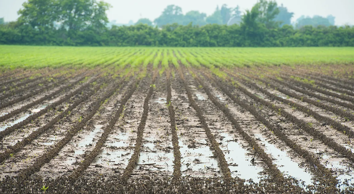
Following one of the wettest Septembers on record, soil moisture levels across much of Iowa are unusually high heading into winter. While that moisture could provide a buffer against drought, it also raises questions about field conditions when planting begins next spring.
Eric Snodgrass, senior science fellow at Nutrien, says some weather conditions offer clues about what lies ahead, but the farther out the forecast, the less certain it becomes.
“The spring risk for 2027 is not an El Niño risk, it is a wet-soil risk carried over from this fall, plus whatever the winter adds,” Snodgrass says.
A wet start to 2027?
Iowa recorded 7.83 inches of statewide average precipitation in September, 225% of normal and the fourth-wettest September on record. The April-through-September period totaled 30.53 inches, approximately 120% of normal and the ninth-wettest such period since 1895.
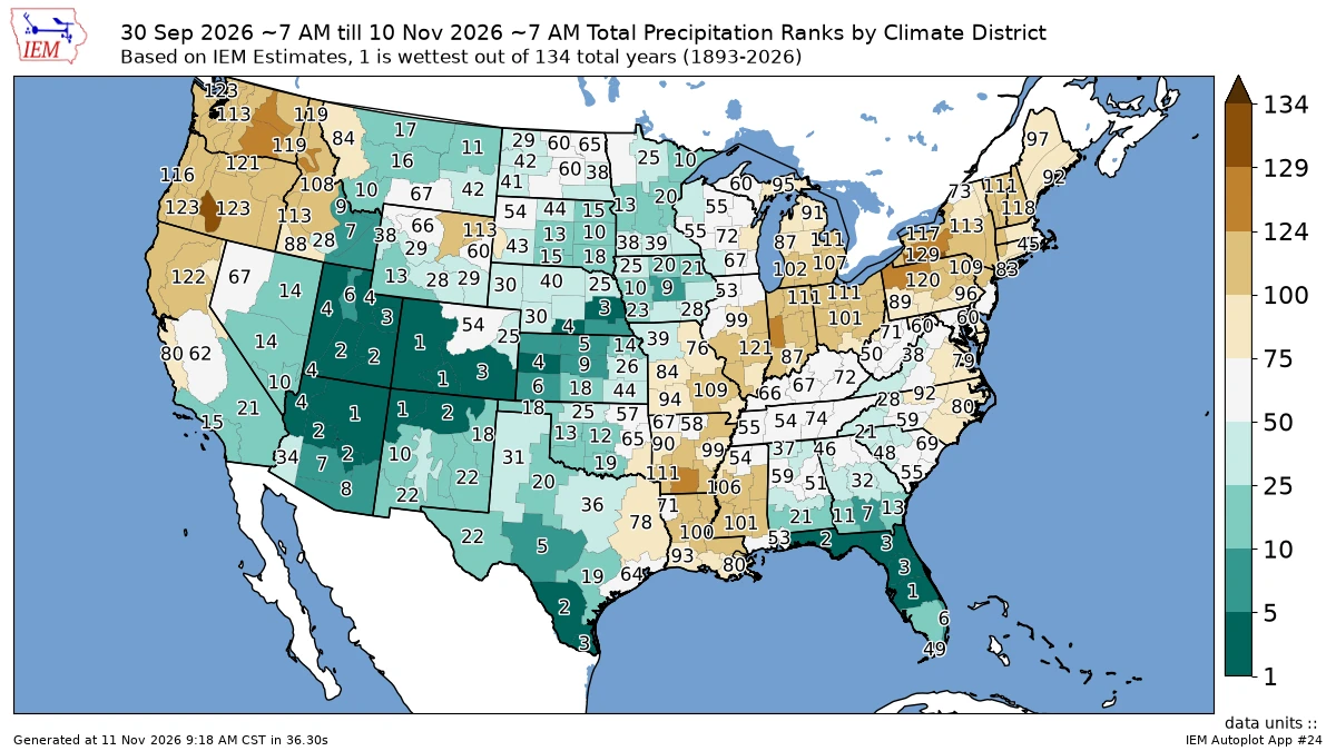
This map shows precipitation rankings by climate district from Sept. 1 through Nov. 11, 2026. Widespread fall rainfall left much of Iowa with saturated soils heading into winter, raising concerns about field conditions for spring planting. (Source: NOAA and Iowa Environmental Mesonet, Iowa State University)
The growing season began with a particularly wet April, followed by a relatively dry May and near-normal precipitation in June and July. Rainfall increased again in August before September’s excessive moisture slowed harvest progress.
“Soil moisture is the one piece of the climate system with genuine memory over several months,” Snodgrass says.
Unlike atmospheric weather patterns that can change quickly, soil moisture conditions can influence the landscape for months.
Saturated soils entering winter could mean tile drainage systems continue running into March. If spring precipitation is average or above normal, fields may have less capacity to absorb additional rainfall, increasing the likelihood of ponding and delayed planting.
However, a difficult spring is not guaranteed. Winter precipitation and the timing of spring rainfall will ultimately determine how quickly fields become suitable for planting.
There is also a positive side to the moisture. For much of the past decade, Iowa has entered winter with some degree of drought that required adequate spring rainfall to overcome. That isn't the situation heading into 2027.
What El Niño could mean
A particularly strong El Niño is another major weather development heading into 2027.
Snodgrass says the event has reached historically high sea surface temperatures in the equatorial Pacific and is expected to remain strong through much of the winter.
El Niño occurs when waters in the central and eastern tropical Pacific become warmer than normal, influencing atmospheric circulation and weather patterns around the globe.For Iowa, strong El Niño winters generally favor warmer temperatures, less snow cover and fewer prolonged outbreaks of Arctic air. According to Snodgrass, historical comparisons show January through March temperatures across the Corn Belt average approximately 3 degrees above the long-term trend during strong El Niño events.
Those conditions could influence soil frost depth, winter water movement and how quickly fields warm during early spring.
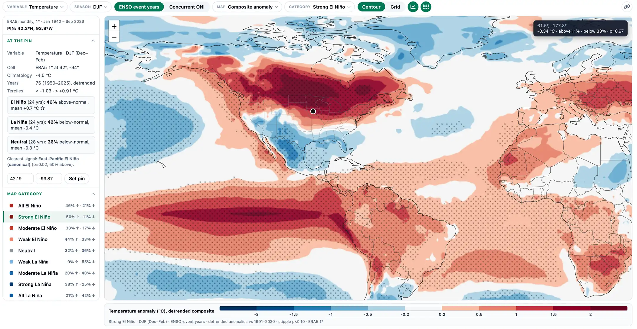
Historical weather patterns show that strong El Niño events generally favor warmer winter temperatures across the northern Plains and Upper Midwest. Those conditions can influence snow cover, soil frost depth and how quickly fields warm in early spring. (Source: ECMWF ERA5 Reanalysis)
But El Niño’s influence becomes much less reliable as the growing season approaches.
Snodgrass examined seven Iowa springs following strong El Niño winters. Two were wet, three had near-normal rainfall and two were dry. Temperatures were similarly mixed.
Climate projections cited by Snodgrass suggest El Niño could weaken through spring, with neutral Pacific conditions becoming more likely by summer.
Summer remains a question mark
Historical growing seasons following strong El Niño events have produced dramatically different outcomes.
The summer of 1983 brought severe heat and drought, while 1992 was unusually cool. The 1998 and 2016 growing seasons featured generally favorable conditions and record yields.
“The El Niño we have now tells us almost nothing about next summer in Iowa,” Snodgrass says.
Instead, he'll be watching ocean temperatures in the North Pacific and North Atlantic. Colder-than-normal water in certain regions, combined with declining soil moisture during June, can increase the likelihood of summer heat and drought.
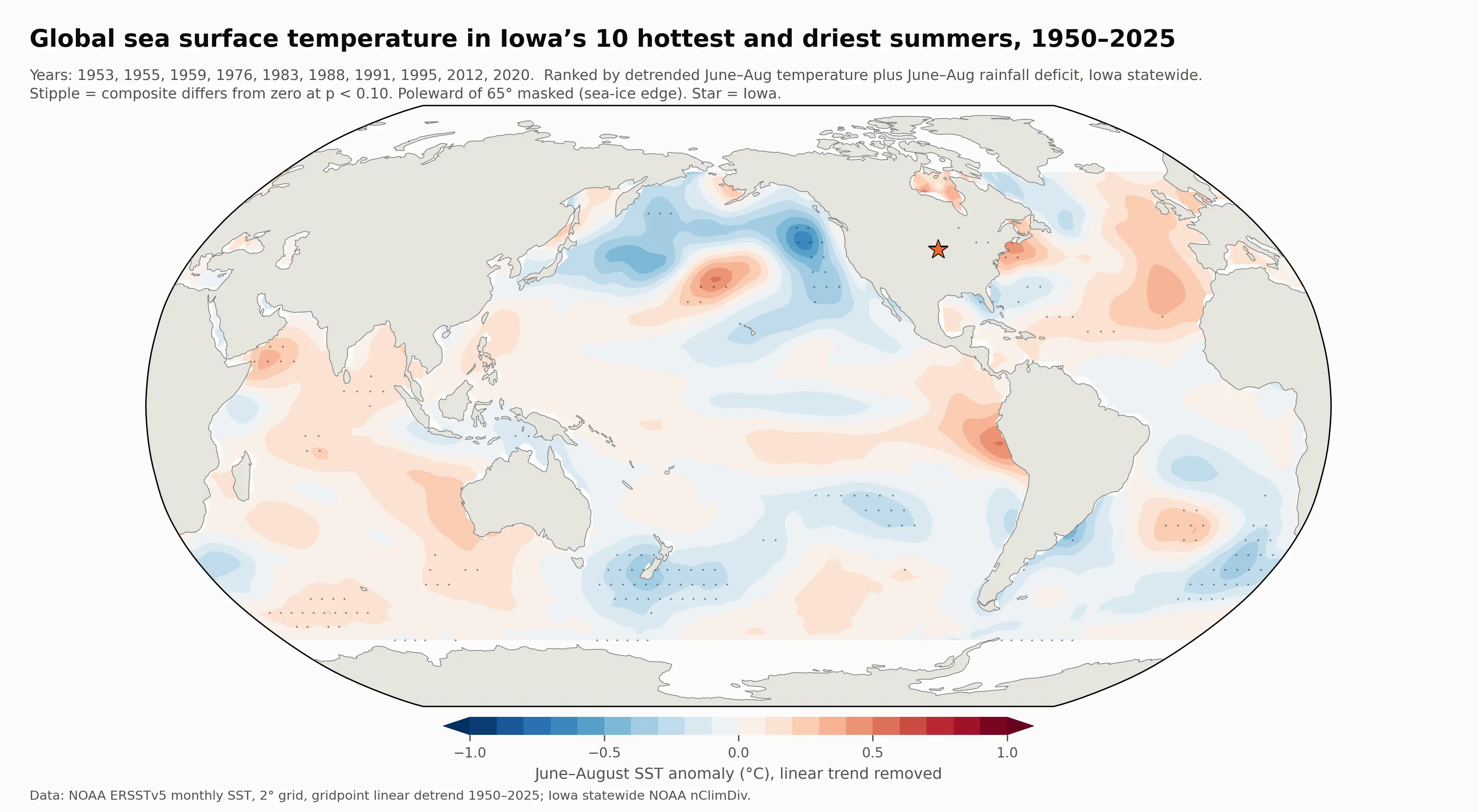
Historical ocean temperature patterns associated with Iowa's hottest and driest summers show why climatologists monitor the North Pacific and North Atlantic. Colder-than-normal waters in these regions can be associated with an increased risk of summer heat and drought. (Sources: NOAA ERSSTv5 and NOAA nClimDiv)
La Niña, which develops when tropical Pacific waters become cooler than normal, is another factor worth monitoring.
Snodgrass says summers with an established La Niña have historically leaned warmer across Iowa, although the relationship isn't strong enough to guarantee a particular outcome.
The placement of high-pressure systems across the western United States also matters. A persistent ridge extending into the Plains and Midwest can redirect storm systems northward, allowing hot, dry conditions to develop.
Soil moisture will remain an important indicator. Wet soils generally promote cooler, more humid conditions, while dry soils can contribute to hotter afternoons.
Could another wet September be ahead?
The excessive rainfall that complicated Iowa's 2026 harvest also raised concerns about soybean quality.
Persistent warm, wet conditions created an environment favorable for seed decay, purple seed stain and other late-season diseases.
September averaged approximately 4.6 degrees warmer than normal statewide, making it the fifth-warmest September on record. Combined with high humidity and frequent rainfall, those conditions kept mature soybean pods wet for extended periods.
Similar concerns emerged in 2018, another year with exceptionally heavy September rainfall. But Iowa's historical weather records show little relationship between September rainfall in one year and rainfall during the following September.
Nor does El Niño provide a reliable indication of late-season precipitation.
“It is beyond what seasonal forecasts can reliably predict, and I would be doing a disservice to pretend otherwise,” Snodgrass says.
Instead, shorter-range forecasts offer farmers more useful information. By mid-August, forecasters can often begin identifying patterns that could influence conditions during late August and early September.
Those outlooks can help guide harvest order, drying plans and other time-sensitive decisions.
Snodgrass points to a longer-term trend toward heavier rainfalls across Iowa. Annual precipitation has increased by roughly 4 inches since the mid-20th century, with a growing share falling during heavy-rain events.
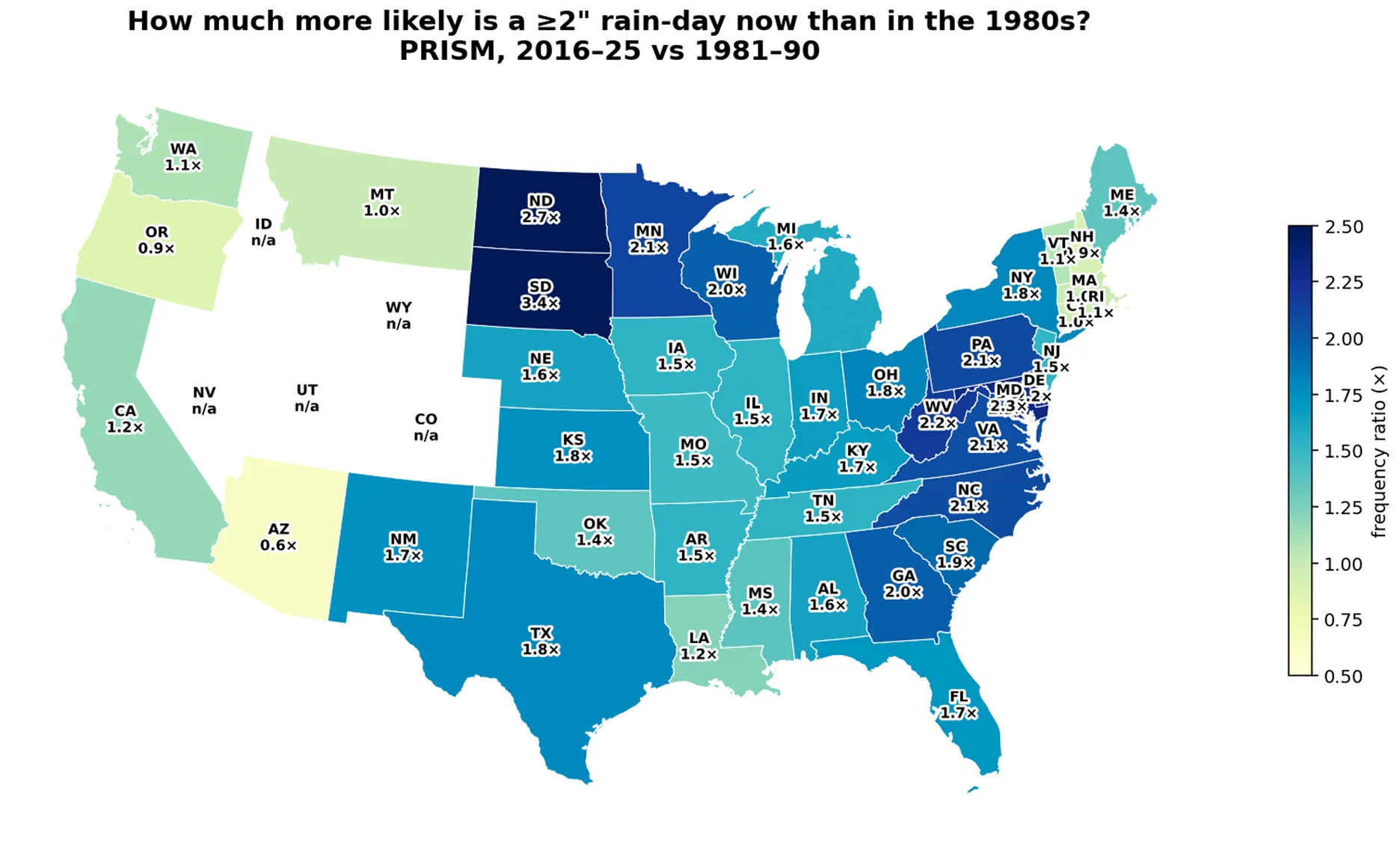
This map shows changes in the frequency of heavy rainfall events exceeding 2 inches in a single day from 1981 to 2025. The data illustrate how the occurrence of intense rainfall has changed across the region over time. (Source: PRISM)
That doesn't mean every fall will be wet, but it makes planning for weather-related harvest challenges increasingly important.
Should soybean maturities change?
After the seed quality problems experienced in 2026, some farmers may wonder whether selecting later-maturing soybean varieties could help avoid unfavorable September conditions.
Snodgrass cautions against making maturity decisions based on a long-range weather outlook.
Later-maturing varieties might avoid some September weather risks, but they introduce others. Shorter days, cooler temperatures and heavier dews in October can slow soybean drydown and delay harvest.
A later soybean harvest may also overlap with corn harvest, fall fertilizer applications and other fieldwork.
Choosing earlier-maturing varieties has trade-offs, too. While earlier maturity can provide more harvest flexibility, soybeans may still be exposed to warm, wet September weather.
Rather than relying on a prediction for one particular month, Snodgrass suggests considering a range of maturities across the farm. Spreading maturity dates can help reduce the likelihood that all fields reach a vulnerable growth stage during the same stretch of unfavorable weather.
“Diversification is the one strategy that does not require a forecast to be right,” Snodgrass says.
Variety characteristics, including seed disease tolerance and shatter resistance, also deserve consideration where quality concerns have been recurring.
Snodgrass emphasizes that maturity and variety decisions should ultimately be guided by agronomists, seed specialists and farmers familiar with their individual fields.
Planning for weather variability
Beyond variety selection, Snodgrass says the wet conditions heading into winter could affect decisions about spring fieldwork and nutrient management.
Fields that were rutted or compacted during a wet harvest may require attention before planting. He also recommends checking drainage outlets and surface inlets and identifying fields that typically take longer to dry.
Heavy rainfall and saturated soils can increase the potential for nitrogen losses, making application timing and weather conditions important factors in fertilizer planning.
Split applications, in-season sidedressing and nitrogen stabilizers are among the options farmers can discuss with their agronomists when evaluating weather-related risks.
Keeping field-level rainfall and soil condition records can also help farmers understand how their land responds to changing weather.
For decisions involving fieldwork and nutrient applications, Snodgrass recommends relying more heavily on two- to three-week forecasts rather than seasonal predictions issued months in advance.
A clearer picture of spring planting conditions should begin emerging by mid-March, when the effects of winter precipitation, frost depth and remaining soil moisture become easier to assess.
Late April through mid-May will provide an important forecasting window. By then, climatologists should have a more reliable picture of how quickly El Niño is weakening and whether La Niña could develop during summer.
Ocean temperatures and atmospheric patterns will also offer additional clues about potential heat and drought risks.
“The confident summer calls you will hear this winter should be treated with the same skepticism you would apply to a yield forecast made at planting,” Snodgrass says.
Written by Kriss Nelson.
Back